


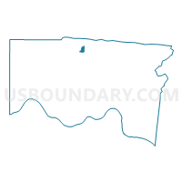
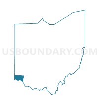
Voting District COLERAIN SS, Hamilton County, Ohio
About
Outline

Summary
| Unique Area Identifier | 647699 |
| Name | Voting District COLERAIN SS |
| County | Hamilton County |
| State | Ohio |
| Area (square miles) | 0.47 |
| Land Area (square miles) | 0.47 |
| Water Area (square miles) | 0.00 |
| % of Land Area | 100.00 |
| % of Water Area | 0.00 |
| Latitude of the Internal Point | 39.27843090 |
| Longtitude of the Internal Point | -84.56926080 |
Maps

Graphs
Select a template below for downloading or customizing gragh for Voting District COLERAIN SS, Hamilton County, Ohio


Neighbors
Neighoring Voting District (by Name) Neighboring Voting District on the Map
- Voting District COLERAIN GG, Hamilton County, OH
- Voting District COLERAIN I, Hamilton County, OH
- Voting District COLERAIN MM, Hamilton County, OH
- Voting District COLERAIN OO, Hamilton County, OH
- Voting District COLERAIN Y, Hamilton County, OH
- Voting District FOREST PARK R, Hamilton County, OH
- Voting District SPRINGFIELD FF, Hamilton County, OH
- Voting District SPRINGFIELD M, Hamilton County, OH
Top 10 Neighboring County Subdivision (by Population) Neighboring County Subdivision on the Map
- Colerain township, Hamilton County, OH (58,499)
- Springfield township, Hamilton County, OH (36,319)
- Forest Park city, Hamilton County, OH (18,720)
Top 10 Neighboring Place (by Population) Neighboring Place on the Map
- Forest Park city, OH (18,720)
- Northgate CDP, OH (7,377)
- New Burlington CDP, OH (5,069)
- Pleasant Run CDP, OH (4,953)
- Mount Healthy Heights CDP, OH (3,264)
Top 10 Neighboring Unified School District (by Population) Neighboring Unified School District on the Map
- Northwest Local School District, OH (74,442)
- Winton Woods City School District, OH (26,533)
- Mount Healthy City School District, OH (24,410)
Top 10 Neighboring State Legislative District Lower Chamber (by Population) Neighboring State Legislative District Lower Chamber on the Map
Top 10 Neighboring State Legislative District Upper Chamber (by Population) Neighboring State Legislative District Upper Chamber on the Map
Top 10 Neighboring 111th Congressional District (by Population) Neighboring 111th Congressional District on the Map
Top 10 Neighboring Census Tract (by Population) Neighboring Census Tract on the Map
- Census Tract 215.09, Hamilton County, OH (6,625)
- Census Tract 215.08, Hamilton County, OH (5,941)
- Census Tract 215.72, Hamilton County, OH (5,845)
- Census Tract 205.05, Hamilton County, OH (4,725)
- Census Tract 205.04, Hamilton County, OH (3,743)
- Census Tract 215.71, Hamilton County, OH (3,402)